A lot around here.
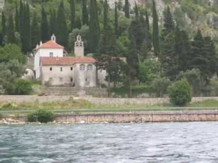
On the edge of Risan there is an old monastery, Banja, claimed to have been founded originally by Stefan Nemanja in the 12th century, though the present buildings date from its reconstruction in the early 18th century.
Within the old part of the town is the church of St Peter and St Paul, built in 1796, and the rather sad ruins of the Venetian-era baroque Ivelic palace. Near the spring in Smokovac is the church of St John and St Luke.
Crkvice
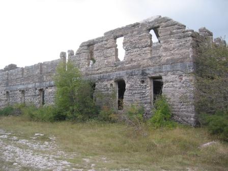
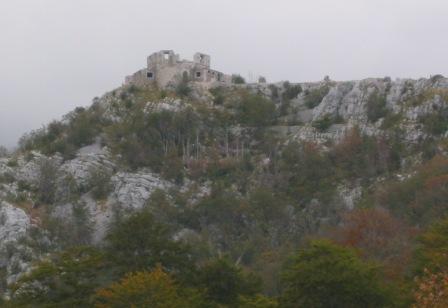
There are many Austrian forts up in the hills, with military roads linking them. Sadly there is almost no published information about them. There is a group of fortification enthusiasts, mainly Austrian, one of whom, Volker Pachauer, we met in 2011 in Graz, and who most kindly gave me a CD of his Master’s Thesis on the forts along the Montenegrin coast. As it is in German, I need to translate it before putting any excerpts on this website. They have a website devoted to all Austo-Hungarian fortresses.
Recently, the Austrian government has financed the creation of signed hiking trails along the hills. As there are no restaurants let alone hotels up there, hikers have to descend to the coast to eat and sleep.
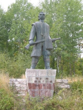
At Crkvice, there is a monument to the victory of 1869 against the Austrians who were attempting to enforce compulsory military service.
A few km along the road is a massive bakery for the Austrians forces garrisoned along the ridge-line, relatively close to two of the many forts (Streza and Kum – at least that’s what the name sounds like).
In the Boka just off Perast there are two islands, each with a monastery on it – Sveti Djordje
(privately owned) and Gospa od Skrpjela (open to the public).
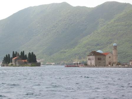

Perast, seen here from Gospa od Skrpjela, is a lovely little Venetian style town with most of its original stone buildings well restored. See http://adriaticclub.tripod.com/businesscard/id9.html for more details.
At the southern end of the Boka, Kotor is one of the main tourist destinations in Montenegro. Cruise ships call daily during the summer. The multi-walled Old Town is a lovely maze of cobbled streets. Anyone fit enough can climb up the longest wall surrounding the town to the castle above (take plenty of water, and don’t try it during the heat of the day!!).
For nature lovers, the Orjen range (highest point 1894m) is an amazing wilderness area with forests and plant life waiting to be found. We have still to get up there to do some serious exploring. The Kameno More or ‘stone sea’ is an accurate description of this typical karst landscape. Our local doctor friends say that the area is rich in medicinal plants.
Pot Holes/ Caving
As one might expect from limestone terrain, there are a mass of underground caves, tunnels, water-courses etc. A British group of pot-holers came out in 2009 and returned in July 2010 & 2011 to explore the caves near Ledenice.
A note from Chris Binding before the 2010 expedition:
” … We’re a 12 strong team this year (8 strong in 2009) and have two prongs to our expedition; firstly is a revisit to an “unfinished” cave, insofar as there’s more of it than we had time to explore and it has massive potential to yield far more passage, depth and water than we’ve found so far. Secondly, about half the team intend to do a lot of surface prospecting; … we have a few other caves to descend which we found last summer, too. In all, the exploration work has been going on since 1999, with expeditions in 2003, a UK-involved team in 2004, and then again in 2009. The momentum has been building up, largely off the back of the main cave which we’ve descended to around -400m with another 300m depth potential (to the water table/ resurgence in Risan Bay). The outflow is huge so there’s a subterranean river system down there somewhere, as yet unlocated. We have a strong team of rope technicians and some highly experienced veteran expeditioners, too, with a good background in science, surveying, photography etc. …
We expect the cave (named PT4) to lead down to a subterranean river which (most likely) re-emerges at Sopot and/or Spila in Risan Bay. From a caver’s point of view Kameno More is FANTASTIC! … ”
A follow-up note from Christopher after their expedition in July 2010:
“… Firstly, our main push was 99% successful insofar as we have confirmed the cave, PT4, as the 7th deepest in Montenegro, adding a further 4 vertical drops to the system and approximately 130 metres of surveyed depth; since 2009 the surveyed length of the cave has increased six-fold as a result of the team’s efforts. More significantly we have a good archive of photographs and film of this year’s work and this will form a presentation to the UK National Conference in September: once I have edited/finished the film I shall gladly upload it so you can view the kind of stuff we’ve been up/down to!
The cave “ended” at a sump (submerged/underwater passage) and plans are already afoot to return with cave divers but that’s going to be a more logistically demanding trip so don’t “hold your breath” waiting for fast results. We did not find the huge subterrranean river system feeding Sopot/Spila so there’s plenty to play for.
Surface recce team members also located a number of exceptionally promising sites with similar features to PT4 so there’s masses more scope for Montenegrin caving exploration. …”
I got this report from a member of the 2011 team, Joe Duxbury:
” … Firstly the sump in the deep cave PT4 only went down for about 2m before being blocked by sand. It is believed that this is brought up in times of flood, then left behind when the water recedes. Nevertheless we continued to search the surrounding area, and found many other holes, of varying depths, but mostly blocked. One of last year’s leftovers, AS Meander Cave, went down to about 200m, ending in a chamber with no ways on. We found/were shown a cave with water in it, which had been visited before, in the 80s, about which I’m trying to find more. As water is a rare characteristic of caves in this area, it is very promising. … “